
MapInfo Professional version 8.5 is the latest version of MapInfo’s desktop GIS software. The goals of the latest release of MapInfo Professional are to:
- Simplify high quality location enablement
- Provide greater analytical capability
- Simplify and speed up analysis
This review discusses the new features and enhancements of the latest version of MapInfo Professional. MapInfo continues to enhance the functionality of the software based on user suggestions. MapInfo Professional maintains the Windows XP certification for its desktop GIS software along with support for Citrix and Microsoft Terminal environments.
Web Services Enhancements
The latest version of MapInfo Professional provides the ability to connect to servers running MapInfo’s MapMarker and Envinsa software products as well as MapInfo’s Envinsa On-Line Services (EOLS). EOLS provide users with access to functionality without the need for additional software and/or data in-house. The Web services can be accessed via the Internet on a subscription basis, which expands the value of MapInfo Professional with minimal internal resources and without the need for additional capital investment.
MapMarker is a geocoding product that assigns coordinates to an address based on how well that address matches entries in MapMarker’s internal address dictionary. MapMarker v11 or higher is required to use the MapMarker connectivity option. Geocoding functionality can be accessed through the Table menu by choosing the Geocode Using Server option. First, the user will be asked to specify the geocoding server and the geocoding server preferences – Input, Output, Table Options, Common Options and Advanced Output. Users can then geocode a table of addresses interactively or automatically, as if the geocoding engine was installed on their local computer.
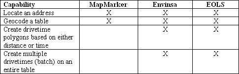
The Envinsa server product provides a wider range of Web services than MapMarker server. Envinsa can be purchased as a product or can be accessed as an online subscription service. Table 1 shows the Web services that MapInfo Professional v8.5 can access through MapMarker and Envinsa. Additional Web services will be provided in future releases of MapInfo.
Web Services Enhancements
The latest version of MapInfo Professional provides the ability to connect to servers running MapInfo’s MapMarker and Envinsa software products as well as MapInfo’s Envinsa On-Line Services (EOLS). EOLS provide users with access to functionality without the need for additional software and/or data in-house. The Web services can be accessed via the Internet on a subscription basis, which expands the value of MapInfo Professional with minimal internal resources and without the need for additional capital investment.
MapMarker is a geocoding product that assigns coordinates to an address based on how well that address matches entries in MapMarker’s internal address dictionary. MapMarker v11 or higher is required to use the MapMarker connectivity option. Geocoding functionality can be accessed through the Table menu by choosing the Geocode Using Server option. First, the user will be asked to specify the geocoding server and the geocoding server preferences – Input, Output, Table Options, Common Options and Advanced Output. Users can then geocode a table of addresses interactively or automatically, as if the geocoding engine was installed on their local computer.
The Envinsa server product provides a wider range of Web services than MapMarker server. Envinsa can be purchased as a product or can be accessed as an online subscription service. Table 1 shows the Web services that MapInfo Professional v8.5 can access through MapMarker and Envinsa. Additional Web services will be provided in future releases of MapInfo.
Envinsa servers and EOLS require more security than MapMarker servers so users will need a username and password to access Envinsa services. Users can connect to EOLS through an option in the MapInfoHelp menu. Users can register for a free 90-day EOLS trial account that is good for 1,000 free credits to test out the Web services. To create geographic data in the US or Canada, one credit can be used to geocode one address and one drivetime polygon can be created for one hundred credits.
Figure 1 shows the Find Address dialog box for the MapInfo Envinsa or MapMarker Geocoding Web Service. Users can enter the address information to locate an address. The Web service can also switch between addresses in multiple countries. The user types the address into the fields and the results will be shown in the list-box. The user can then select the correct address in the results list box and press the Add to Map button to add a point symbol to the map.
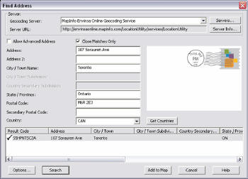
Figure 1 shows the Find Address dialog box for the MapInfo Envinsa or MapMarker Geocoding Web Service. Users can enter the address information to locate an address. The Web service can also switch between addresses in multiple countries. The user types the address into the fields and the results will be shown in the list-box. The user can then select the correct address in the results list box and press the Add to Map button to add a point symbol to the map.
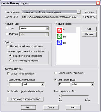
The Envinsa or EOLS Drivetime Web Service uses the latest road networks and search algorithms to create polygons based on driving distance or time from a specified location. The routing server for the Drivetime Web Service will need to be configured in the Web Services category of the Options > Preferences menu. To create drivetime polygons, select Driving Regions from the Objects menu. Figure 2 shows the options within the Create Driving Regions dialog box. Drivetime polygons will be created on the Envinsa server based on the options selected, and a TAB file of the drivetime polygon will be added to the MapInfo workspace and can be saved permanently to the local computer.

Download Software MapInfo Professional Version 8.5
>> MapInfo 8.5 Part 1 <<
>> MapInfo 8.5 Part 2 <<


3 komentar:
“Opportunity is missed by most people because it is dressed in overalls and looks like work.” – Thomas Edison -
"We all pay taxes to stupidity. Some of us become far-gone in the process." - Marius Torok - (1977)
.
Post a Comment